Days 15 & 16: Tech Breaks and Rest Day
- Joe.Cannon

- Sep 20, 2025
- 4 min read
The last two days have had their ups and downs. Of course, when you are on a long bike ride, there are lots of ups and downs. On Day 15, I rode from Crescent City to Trinidad. Day 16 was a rest day in Trinidad.
A quick apology to those of you commenting on the blog. I noticed some initial comments (right after a post), but just now saw there were more comments. I will try to stay on top of those and respond.
And some bad news. No Relive video for Day 15. See why below.
Riding
Day 15: 57.8 miles, 4025 elevation (2 wheeeeeeeeeeees!)
This ride, from Crescent City, California to Trinidad was very interesting. First, right out of town, there was a huge climb. The climb was 5 miles and 1300 feet. The first 2.5 miles were 8-9% grade (that is tough to ride at a steady pace). Those climbs usually mean the highway has three lanes (a passing lane going uphill), but that also means very little shoulder on my side. I have a future blog post brewing about how I handle those situations and try to stay safe.

The best thing about those long climbs is the long descent. And this one was long and special (thus, all the extra "e's" in wheee, above). Maybe a couple of miles down, there was road work. They closed one side to traffic. So you had a flagman and also a "pilot truck" that would take turns leading each side through the half mile or so the road was closed. I cruised past the line of stopped cars and asked the flag guy how he wanted me to handle things. He said that I should go out ahead of the pilot truck on the way down and they would give me a head start. The pilot truck driver told me to "Go like hell!" I was flying down my side, knowing there would be no cars. 6-8% downhill grade for about 2.5 miles. It was awesome. Wheeeeeeeeeeeee!

About 40 miles into the ride, I had just ridden over a rumble strip (that bumpy stuff just off the highway). I looked down at my trust Garmin bike computer and what did I see...
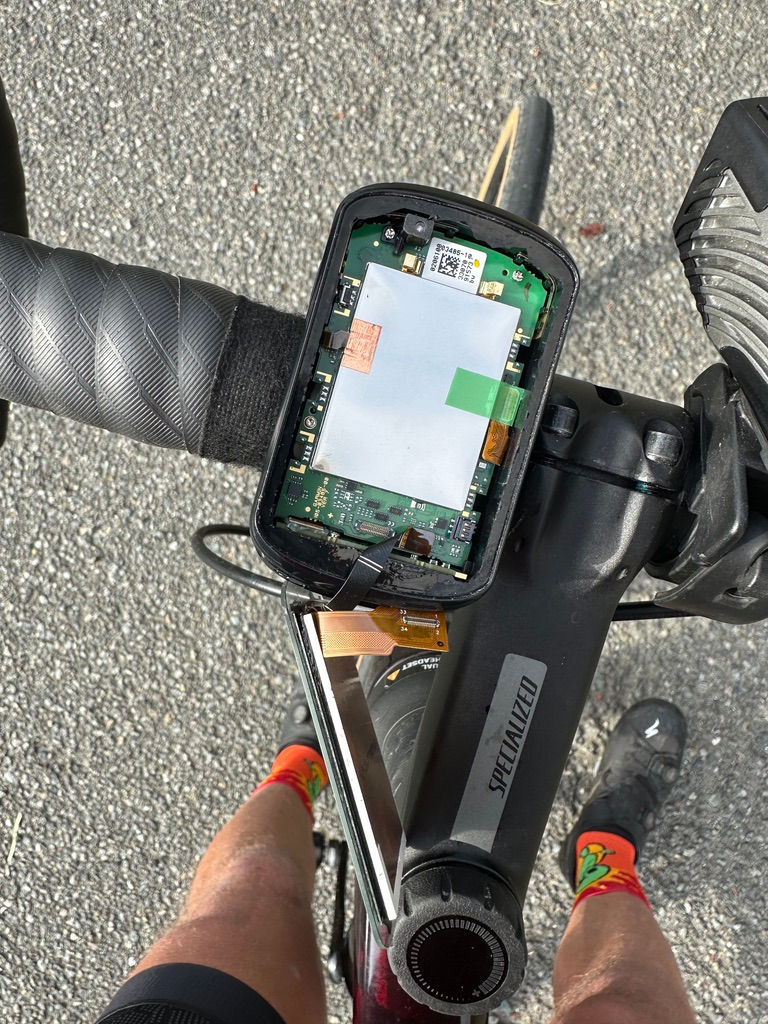
...the top had popped off of my Garmin. Popping it back on didn't fix it. In fact, the little ribbon holding the top there quickly broke. That bike computer records my rides and allows me to upload the rides to my social media (Strava) and to Relive (for those videos that many of you enjoy). I was fortunate enough to find a new one in Arcata (about 7 miles from Trinidad) and picked on up the same afternoon. Whew!
The ride passed some more of those beautiful (by now) boring (haha, just kidding) coastlines. I also passed the Trees of Mystery as well as Paul Bunyan and Babe the Blue Ox.

I also got my first opportunity to ride among the giant redwoods on the 10 mile long Newton B. Drury Scenic Parkway. It was so cool being right in the trees (the highways have cut them back so far, it is quite different).

The last 10 or so miles into Trinidad had some of the riskier riding I have seen. In fact, the guy at the bike shop where I bought the Garmin asked me what I thought, telling me that a lot of bikepackers complain about it. The road had a lot of curves and many parts with less than 12 inches of shoulder. It was a bit hairy.
Day 16: 0 miles, 0 elevation - Rest Day
Chris and I made the most of our rest day here in Trinidad (and the surrounding area). The day we arrived, we explored Trinidad State Beach on the west side of town and then wandered through "downtown" Trinidad (2 blocks long). Trinidad has just 300 residents, but it has plenty of scenic vistas.
Today (Saturday, the official rest day), we were busy. We returned to Scenic Parkway and Prairie Creek Redwoods State Park, hiking from the Cathedral Trees to the Prairie Creek Trail. We saw lots of big trees, including "THE BIG TREE." If you cannot read the sign between Chris and me, allow me to help. The tree is 289 feet tall, 23.7 feet across, 74.5 feet in circumference, and about 1500 years old. It is really impressive in person.

From there, Chris and I went to the Lagoons area, with some beautiful coastline, freshwater lagoons, and a couple of shorter hikes. After that, we went out to Patrick's Point (closer to Trinidad) for another hike out to the coast. After that, I did some bike maintenance (new rear tire and lube for the chain). Tonight we split a fried fish dinner in town and got back to our place (the Trinidad Inn) early to get ready for the next leg of our journey.

![Days 31 to 33: The people you meet [Lots of photos, may load slowly]](https://static.wixstatic.com/media/f3ebae_1d9305e1b33e4cc786499cdfd9f6e0f4~mv2.jpeg/v1/fill/w_980,h_735,al_c,q_85,usm_0.66_1.00_0.01,enc_avif,quality_auto/f3ebae_1d9305e1b33e4cc786499cdfd9f6e0f4~mv2.jpeg)

Love following you on this journey. One of my favorite rides is from The Russian River to Bodega Bay on the coast. It's 11 miles. Great motel in Bodega Bay and 2 great restaurants in town. This is where the movie The Birds/Alfred Hitchcock was filmed. Enjoy. Bob Loner
Heck of an adventure! Love the Wheeeee story.
Looks like a great trip! I bet your Garmin fail was a surprise.
Great update and it can be nice when they do the road closure that way. Hopefully, you took this oppertunity to upgrade Garmin to the 1030 or 1050 “plus” models with bigger screens? Easier for navigation and for the radar alert if you use the Garmin radar light on the back. I carried a spare Garmin in the bike repair bag last year cross country (an 820) for exactly the reason your picture describes. Never had to use it.